
|
Just
around the river bend Photos and
Story A winding,
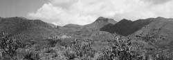
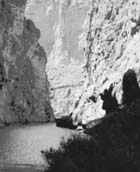
lazy river cuts 1,500-foot-deep canyons through limestone rock.
A vast desert, which can reach temperatures of 120 degrees in the
summer, stretches as far as the horizon will allow. And 8,000-foot
jagged mountains shoot out of the ground, seemingly touching the
sky. Tucked away in southern Texas along the Rio Grande is still one of the nation’s most beautiful national parks. Big Bend, as the Apache Indians called it, features some of the most stunning natural scenery in the United States, as well as some of the best hiking in the Southwest. The park, located in the Chihuahuan Desert, runs along the Rio Grande, the southern border between Mexico and the United States. As the river winds southward, it suddenly veers north in a horseshoe curve before it continues its voyage to the Gulf of Mexico. Inside the horseshoe lies the area known as Big Bend. Mark Willey, a park ranger at Big Bend for nine years, said the park has some of the most unique geological sites in the country. “This is the only park I know where you can see mountains rising up out of the desert floor, giant canyons with 2,000 foot drops, on of the most beautiful rivers in Texas, and some very unique wildlife,” Willey said. “Not many people across the nation know about (Big Bend), but that’s what kind of makes it nice.” The groundwork for Big Bend was laid about 200 million years ago. Two seas, one after another, flowed and receded in the region leaving thick deposits of limestone and shale. About 125 million years later the present mountains, except for the Chisos, uplifted to form some of the smaller mountains in the park. During that same time a 40-mile-wide trough sank along fault lines, leaving the Santa Elena Canyon to the west, and the Sierra Del Carmen to the east. Forty million years later volcanic ash spewed into the air from one of several active volcanoes and molten lava flowed to the surface, forming the Chisos Mountains. Big Bend also is home to more than 1,000 different plant species, some of which can’t be found anywhere else in the world. Vegetation includes several different types of cactus, more than 25 different types of wildflowers and many different types of trees. The park also includes more than 400 different types of birds, more than any other national park in the nation. “Besides the obvious beauty of the park, a lot of people come down here to birdwatch,” Willey said. “The reason there are so many birds is because we are in the migration flight path from Central to South America.” When exploring the park, it is best to allow several days, especially if you plan on hiking. The Chisos Mountains Basin and the Santa Elena Canyon provide two of the park’s most dramatic backdrops. When exploring the Chisos Mountains, the southernmost mountain chain in the United States, be sure to stop at Pulliam Bluff. The lookout provides one of the most spectacular views of the mountain chain and has it that you can see the profile of legendary Apache Indian chief Alslegendate on the side of the peak. On certain nights it is said that if you look closely enough you can see Alsate’s campfire burning on the mountain. Forming the southernmost boundary of Big Bend is the Rio Grande. The river, which actually starts in southern Colorado, forms many of the beautiful canyons that preside on the southern border of the park. Santa Elena Canyon is perhaps the most spectacular. “I’d say that Santa Elena Canyon is something that everyone who comes to this park should see,” Willey said. The canyon, which drops down some 2,000 feet, provides a breathtaking view. If the water level of the river is low enough, take the two-mile round-trip hike down to the canyon floor and enjoy the view of the canyon walls from a different perspective. Big Bend offers visitors three campgrounds on a first-come, first-served basis. Two of the campsites, Cottonwood and Rio Grande Village, are located on the Rio Grande. The other campsite, the Basin, is located on the side of Casa Grande Peak, some 4,500 feet above the surface. John Kirkley, a nature enthusiast who has visited Big Bend nine times, recommends overnight backpacking permits. “If you really want to get out and experience Big Bend, you need to camp far away from the roads and people in the park,” Kirkley said. “It takes a little more effort, but after you camp in the back country for a night you will never think about camping anywhere else.” Overnight backpacking passes are issued on a first-come, first-served basis. Park rangers will help you plan your backpacking trip when you purchase a permit. Chad
Carey
|
 As
you continue on a southern path through the Chisos Mountains you
slowly come upon one of the park’s most physically intimidating
features. Casa Grande, which means “big house,” is one
of the tallest mountain peaks in the park. It rises some 7,325 feet
above the surface and can be seen from much of the park.
As
you continue on a southern path through the Chisos Mountains you
slowly come upon one of the park’s most physically intimidating
features. Casa Grande, which means “big house,” is one
of the tallest mountain peaks in the park. It rises some 7,325 feet
above the surface and can be seen from much of the park.The TCU Daily Skiff
© 1998, 1999, 2000, 2001
Web Editor: Ben Smithson
Contact Us!